We’re all familiar with the extreme conditions of the snow-covered Arctic and most of us know that it’s found at the north pole. But defining the actual boundary of the Arctic can be difficult, so, where is the Arctic?
The Arctic is the region that covers the northernmost parts of the world, from the north pole and extending south. The Arctic is located within the Arctic circle, a line around the world at 66°30′ north. It includes parts of Alaska, Canada, Greenland, Russia, and Scandinavia.
However, there are several other ways of defining where the Arctic is including some climate-based boundaries and those used by different organizations that work there. Keep reading to find out about these.
Where is the Arctic?
As mentioned in the introduction, defining exactly where the boundaries of the Arctic are isn’t as straightforward as you’d think. Here are the four main ways of defining where the Arctic is:
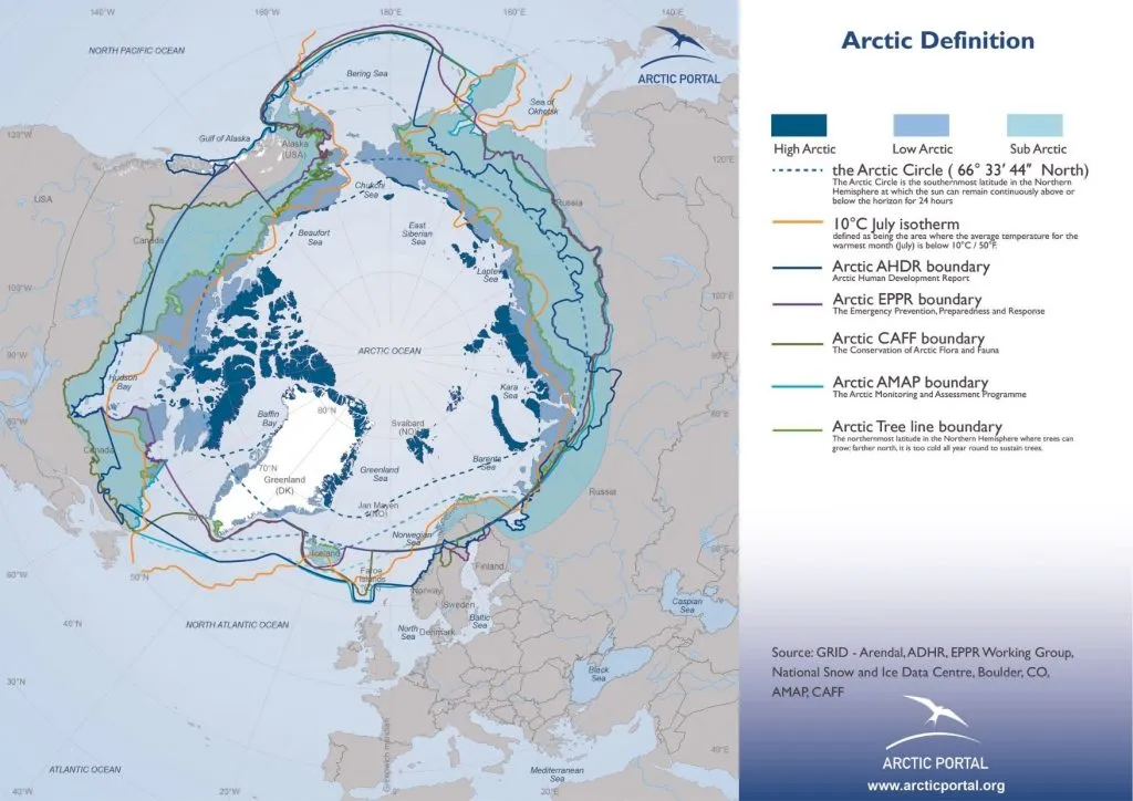
- The Arctic Circle – A line of lattitude around the world at 66°30′ north
- The Arctic Treeline – The boundary at which no more trees can grow
- The Summer Isotherm – The boundary where summer temperatures do not exceed 10°C
- The CAFF Boundary – The boundary used by the Arctic Council’s CAFF working group
The Arctic Circle definition is the most common because it is simple, universal, and will never change. The treeline and the isotherm are climate definitions and may evolve with climate change.
All of the boundaries are vaguely similar as shown in this map from Arctic Portal:
Let’s look at each of the four main definitions of where the Arctic is and why each is used.
1. The Arctic Circle
The most common definition of the location of the Arctic is using the Arctic circle. This is the imaginary line of latitude that goes around the world at 66°30′ N (pronounced 66 degrees and 30 minutes north).
The Arctic Circle lies about 2,600km (1,600 miles) from the north pole.
It marks the southern limit at which you will experience midnight sun, these are days when the sun does not set and shines for more than 24 hours due to the incline of the Earth.
On the Arctic circle, you will experience several days of midnight sun. This increases as you move further north, with the north pole experiencing 6 months of midnight sun.
The Arctic Circle is the opposite of the Antarctic Circle which lies at 66°30′ south.
2. The Arctic Treeline
A second way that people define the Arctic is by the Arctic treeline. This method focuses on the change in growing conditions for plants rather than sunlight as the previous method.
The Arctic is a tundra climate, these are known for being treeless. A tundra is treeless because a permanent layer of frost remains beneath the soil and prevents tree roots from taking hold.
The Arctic treeline is the northernmost point at which trees can grow, beyond the treeline is the Arctic tundra.
This method is very focused on the climate of the Arctic, however, it does not make a perfect circle like the previous method so is much harder to map out.
The treeline method is also used to define alpine tundra which occurs near the top of mountains across the world. Similar to the Arctic tundra, they will also have a treeline.
3. The 10°C Summer Isotherm
Another popular method of defining the Arctic is the 10°C summer isotherm. Similar to the treeline method, this uses the change in growing conditions for plants as its basis.
The 10°C summer isotherm is a boundary that includes anywhere where the average summer temperature does not exceed 10°C.
The summer isotherm draws a similar boundary to the treeline as they are both climate-based definitions. However, the summer isotherm also includes some nearby areas of high altitude that would not be covered by the treeline definition.
4. The CAFF Boundary
A fourth common way of defining the Arctic is the boundary used by the Conservation of Arctic Flora and Fauna (CAFF). This is a working group of the Arctic Council.
The Arctic Council is an international organization made up of the eight countries that fall within the Arctic area. Together, they address issues faced by the Arctic and the indigenous people that live there.
The role of the CAFF working group is to address the conservation of Arctic biodiversity within the CAFF boundary1 (source: CAFF).
The area defined by this boundary is the largest of all the definitions, extending further south than the treeline and summer isotherm in some areas.
Note: Other working groups of the Arctic Council use slightly different boundaries depending upon their needs, such as the Emergency, Prevention, Preparedness and Response (EPPR), and the Arctic Human Development Report (AHDR). But CAFF is the most widely used of these.
Other Definitions
We’ve just covered the main definitions but others include the point where the Arctic Ocean meets the Atlantic and Pacific Oceans or some people use the line of latitude at 60° north.
However, these other definitions are harder to justify than the four main ones shared above.
Related Questions
Is the Arctic in the North or South Pole?
The Arctic is located in the northernmost part of the planet around the north pole and extending south. At the opposite end of the planet, around the south pole, you’ll find Antarctica.
How Big is the Arctic?
Using the common definition of the Arctic which includes everything north of the Arctic circle, the Arctic is 20 million km2 (7.7 million sq mi) which equals about 4% of Earth’s surface.
Marsh, William M.; Kaufman, Martin M. (2012). Physical Geography: Great Systems and Global Environments. Cambridge University Press. p. 24. ISBN 978-0-521-76428-5.
How Big is the Arctic Ocean?
The Arctic ocean is 14.06 million km².
Is the Arctic a Continent?
No, the Arctic is not a continent. Whilst you will find sea ice across most of the Arctic during winter, there is no landmass underneath so when it melts in the summer it becomes open ocean.
Around the edge of the Arctic, there is a landmass, however, this landmass is parts of North America, Europe, and Asia, rather than a separate continent.
This is the opposite of Antarctica which is a separate continent because there is a landmass underneath all the ice and snow at the south pole.
What Countries Are in the Arctic?
Eight countries have territory within the Arctic, these are Canada, Greenland (Denmark), Iceland, Norway, Sweden, Finland, Russia, and the United States.

![You are currently viewing Where is the Arctic? [4 Ways to Define it]](https://polarguidebook.com/wp-content/uploads/2021/07/where-is-the-arctic.jpg)
![Read more about the article Arctic Tundra vs Alpine Tundra [7 Similarities and Differences]](https://polarguidebook.com/wp-content/uploads/2021/08/Arctic-tundra-vs-alpine-tundra-300x176.jpg)